

Table of Contents
Marin County is known for redwoods, coastline and small towns just across the Golden Gate Bridge from San Francisco. It is home to Muir Woods, Mount Tamalpais and Point Reyes National Seashore, and it is one of the most expensive places to live in California. More than half of the county is protected parkland, open space or farmland, which keeps most of its 262,321 residents (2020 census) in a narrow band of towns along Highway 101 and the bay.
What Is Marin, and What Does the Name Mean?
Marin is Marin County, California, the peninsula county directly north of San Francisco across the Golden Gate. The name comes from Chief Marin, a Coast Miwok leader. Locals say Marin for the whole county, never for one city. It is pronounced "muh-RIN."
- Chief Marin was born into the Huimen people, part of the Coast Miwok, and was baptized "Marino" at about age 20. When California's counties were named in 1850, Mariano Vallejo said this one honored the "great chief of the tribe Licatiut."
- A second account traces the name to the Spanish, who in 1775 named the bay between San Pedro Point and San Quentin Point "Bahía de Nuestra Señora del Rosario la Marinera." Marin would be a shortened form of that name.
- Marin is one of California's 27 original counties, created on February 18, 1850. San Rafael is the county seat.
- The county has eleven incorporated cities and towns, from Novato in the north to Sausalito in the south. The full list is in cities and towns in Marin County.
- Marin City is a separate unincorporated community near Sausalito, so Marin and Marin City are not the same place.
What Marin County is known for
- Muir Woods National Monument and its old-growth coast redwoods
- Mount Tamalpais, the county's highest peak, widely called the birthplace of mountain biking for its fire roads
- Point Reyes National Seashore, with its lighthouse, tule elk and long beaches
- Beaches such as Stinson Beach, Muir Beach and Rodeo Beach
- Views of the Golden Gate Bridge and San Francisco from the Marin Headlands and Sausalito
- Small towns with walkable downtowns, from Mill Valley to Point Reyes Station
- The Marin County Civic Center, designed by Frank Lloyd Wright
- High incomes and some of the highest home prices in California; see is Marin County a wealthy area
Geography
Between the bay and the Pacific
Marin sits just north of San Francisco, with the Pacific Ocean to the west and San Francisco Bay and San Pablo Bay to the east. Sonoma County is its only land neighbor. The southern towns of Sausalito, Tiburon and Belvedere face the bay and the city skyline, while Point Reyes and Tomales in the west are rural and rugged. More on its size in how big is Marin County.
Marin County beaches
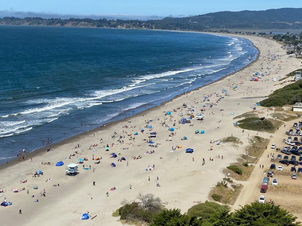
Marin's coast runs from the Golden Gate north to Dillon Beach and the Sonoma County line. The best-known beaches, from south to north:
- Rodeo Beach in the Marin Headlands, known for its pebbly sand and lagoon
- Tennessee Beach, at the end of the Tennessee Valley Trail
- Muir Beach, a small cove below Highway 1
- Stinson Beach, the county's long, sandy swimming and surfing beach
- Agate Beach in Bolinas, with tide pools at low tide
- Limantour, Drakes, and Point Reyes North and South beaches in Point Reyes National Seashore
- Heart's Desire Beach on Tomales Bay, a calmer bay beach
- Dillon Beach at the north end of the county
The Pacific here is cold and the surf can be dangerous, so most of these are for walking and tide pooling more than swimming.
Mountains and forests
Mount Tamalpais, "Mount Tam" to locals, rises above Mill Valley and is the highest point in the county, with views across the Bay Area and the Pacific. Redwood forests fill its canyons, including Muir Woods, and the rolling hills of the Ross Valley, the San Geronimo Valley and the Marin Headlands are laced with trails.
Things to do in Marin County
Hiking trails and parks
Marin has national, state and county parks, including the Marin Headlands, Samuel P. Taylor State Park, China Camp State Park and Mount Tamalpais State Park. Popular hikes include the Dipsea Trail from Mill Valley to Stinson Beach, the Tennessee Valley Trail, and the Alamere Falls hike in Point Reyes.
Muir Woods National Monument
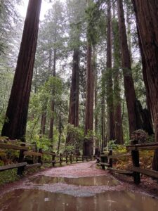
Muir Woods protects one of the last old-growth coast redwood forests near San Francisco. Flat boardwalk trails run along Redwood Creek under trees that are hundreds of years old. Anyone arriving by car or shuttle needs a parking or shuttle reservation, so book ahead.
Point Reyes Lighthouse
The Point Reyes Lighthouse sits on a headland at the western tip of Point Reyes National Seashore. It is a well-known spot for watching gray whales during their migration, and the surrounding park has tule elk, elephant seals and many kinds of birds.
Point Bonita Lighthouse
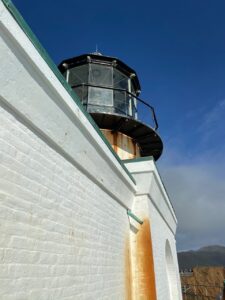
Point Bonita Lighthouse stands at the edge of the Marin Headlands at the entrance to the Golden Gate. Visitors reach it by a short tunnel and a suspension footbridge, with views back toward San Francisco. The lighthouse is open only on limited days and hours, so check the park's schedule first.
Angel Island State Park
Angel Island, reached by ferry from Tiburon, was a Coast Miwok fishing and hunting site, a quarantine station, an immigration station and a military post. Today it is a state park with hiking and biking trails around the island and views of the whole bay.
Marin County Civic Center
The Marin County Civic Center in San Rafael was the last major project designed by Frank Lloyd Wright, with its long, low buildings and blue roof stretched across the hills. It houses county offices and the courthouse, and docent-led tours are offered.
Marin towns
Mill Valley
Mill Valley sits at the foot of Mount Tamalpais, with a small downtown of shops and restaurants under the redwoods. It hosts the Mill Valley Film Festival each fall.
Tiburon
Tiburon is a waterfront town on a peninsula facing San Francisco and Angel Island. Ferries run from its downtown, and the Railroad and Ferry Depot Museum covers its history as a rail terminal.
Sausalito
Sausalito is the first town north of the Golden Gate Bridge, known for its waterfront, houseboats and views of the city. The Bay Model Visitor Center, run by the U.S. Army Corps of Engineers, has a 1.5-acre hydraulic model of San Francisco Bay.
San Rafael
San Rafael is the county seat and the largest city in Marin. Its downtown has Mission San Rafael Arcángel and the Rafael Film Center, which shows independent and international films.
Other Marin communities
Fairfax is known for its music venues and the Fairfax Festival. Novato has a historic Old Town on Grant Avenue. San Anselmo, Larkspur and Ross each have small downtowns, and West Marin towns like Point Reyes Station, Inverness and Bolinas are rural and quiet.
RealVals is a residential appraisal company based in San Rafael that values homes throughout Marin County.
Frequently asked questions
How far is Marin County from San Francisco?
Southern Marin starts on the north side of the Golden Gate Bridge, so Sausalito is a short drive from the city. San Rafael is farther up Highway 101, and Point Reyes Station is about an hour from San Francisco by winding roads. More in where is Marin County.
Who are some famous people who have lived in Marin County?
George Lucas founded Lucasfilm in Marin and built Skywalker Ranch near Nicasio. Robin Williams lived in Tiburon, and members of the Grateful Dead, including Bob Weir of Mill Valley, made Marin their home.
Why is Marin County so expensive?
More than half of the county is protected parkland, open space or farmland, so there is little land to build on, and it sits right next to San Francisco's job market. Limited supply and high demand keep prices among the highest in California. The cheaper areas are listed in the most affordable places to live in Marin County.
Are Marin County schools good?
Marin's public schools are a big draw for families, and school district lines often affect which homes buyers look at. The county has 18 school districts, listed in Marin County school districts.
